The Wyoming Legislature is going through “redistricting,” the once-a-decade process of redrawing the state’s voting districts.
In this video, we’ll see how the current proposed map that lawmakers are working with politically gerrymanders Albany County to decrease the number of Democratic House seats there, while specifically protecting some sitting Laramie County lawmakers.
The current map was adopted by the Legislature’s Corporations Committee, which oversees the early stages of redistricting, on Jan. 12.
Up until then, the committee had been working with a map that reflected Wyoming’s shift in population over the past ten years. Rural areas in Wyoming have lost residents, while more urban areas have grown.
This upset some rural state legislators who do not want to cede power. So a group of them got together and convinced the Corporations Committee to scrap their work and start with a new map that gives them more influence.
In the process, they carved up Albany County in a way that makes it harder for Democrats to get elected and created wild uncertainty for the entire southeastern part of the state, even as they specifically protected some sitting lawmakers.
Albany County blues
In Albany County, House District 14 currently includes a portion of the City of Laramie, which is mostly Democrat, and a portion of rural Albany County, which is mostly Republican.

The district is split almost evenly between Republican and Democratic voters, but currently a Democrat holds the seat, Rep. Trey Sherwood.
The redistricting committee’s new proposed map eliminates the City of Laramie from this district. Instead, it adds a huge swath of rural Laramie County, which is strongly Republican. This will make it basically impossible for the sitting Democratic legislator, or any Democrat, to win an election there.
Right now, Albany County has three Democrats in the Wyoming House. Under the new proposed map, there could be only one. It all depends on how they draw the lines.
Laramie County zigzags
Conversely, the new map goes to great lengths to protect some sitting Laramie County legislators.
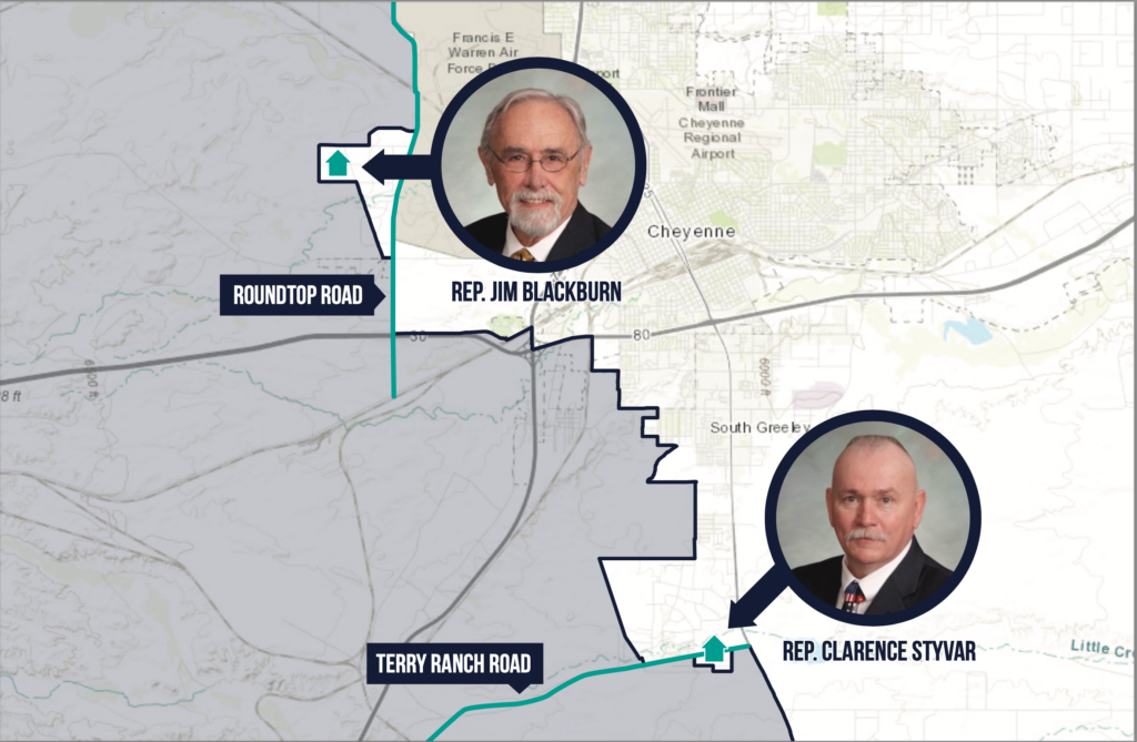
The same new district that would make it impossible for Sherwood to be re-elected stretches all the way to the west side of Cheyenne. Its boundary line there runs along a main thoroughfare, Roundtop Road, but conspicuously zigzags to the west to omit one specific neighborhood.

Similarly, another portion of the boundary line near Cheyenne runs down Terry Ranch Road, also a main thoroughfare, except for a place where it zigzags south to omit another small neighborhood.
Better Wyoming cross-referenced the new district map with the home addresses of sitting Wyoming legislators and found that the neighborhoods specifically carved out from the new proposed district are home to Reps. Jim Blackburn and Clarence Styvar. The zigzagged map is a clear attempt to gerrymander districts to their advantage.
Voting district lines should group together communities of interest. They should be drawn along county lines whenever possible, and otherwise adhere to commonsense boundaries like main roads. Most of all, they should ensure fair and accurate representation of Wyoming’s residents in government.
They should not be used to gain political advantage or zigzag around the map to include or omit specific lawmakers from one district or another, which is simply a means of protecting one’s friends and propping up the Good Ol’ Boys Club.
The Corporations Committee’s next meeting to discuss redistricting takes place on Thursday, Jan. 27, in Cheyenne.